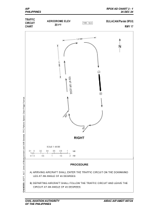


RPUX - Plaridel
Located in Plaridel, Philippines
ICAO - RPUX, IATA -
Data provided by AirmateGeneral information
Coordinates: N14°53'26" E120°51'10"
Elevation is 19 feet MSL.
Magnetic variation is -3° East View others Airports in Bulacan
Operational data
Special qualification required
Current time UTC:
Current local time:
Communications frequencies: [VIEW]
Runways:
| RWY identifier | QFU | Length (ft) | Width (ft) | Surface | LDA (ft) |
| 17 | 174° | 2666 | 54 | ASPH | 2953 |
| 35 | 354° | 2666 | 54 | ASPH | 2953 |
Airport contact information
Address: Plaridel Philippines
Other aviation service providers
Flight schools

Strike Wing Aviation Training Center, Inc.
Strike Wing Aviation Training Center, Inc.
strikewingops@gmail.com+63288523637
Strike Wing Aviation Training Center, Inc.
Strike Wing Aviation Training Center, Inc.
strikewingaviation@yahoo.com+63288523637