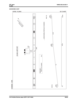


RORE - Iejima
Located in , Japan
ICAO - RORE, IATA - IEJ
Data provided by AirmateGeneral information
Coordinates: N26°43'21" E127°47'13"
Elevation is 238 feet MSL.
View others Airports in Okinawa Prefecture
Operational data
Special qualification required
Current time UTC:
Current local time:
Weather at : RODN - Kadena ( 41 km )
METAR: RODN 041655Z AUTO 08005KT 10SM CLR 19/17 A2991 RMK AO2 SLP134 T01880166 PWINO FZRANO TSNO $
TAF: TAF RODN 041600Z 0416/0522 07009KT 9999 SCT030 QNH2989INS BECMG 0420/0421 08009KT 9999 SCT030 BKN150 QNH2992INS BECMG 0501/0502 09012KT 9999 SCT030 BKN120 QNH2992INS BECMG 0508/0509 09009KT 9999 SCT030 BKN120 QNH2990INS TX27/0505Z TN18/0421Z
Communications frequencies: [VIEW]
Runways:
| RWY identifier | QFU | Length (ft) | Width (ft) | Surface | LDA (ft) |
| 04 | 39° | 4920 | 150 | ASP | |
| 22 | 219° | 4920 | 150 | ASP |
Airport contact information
Address: Japan