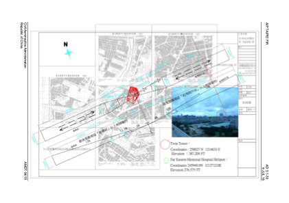


RCH16 - Far Eastern Memorial Hospital
Located in New Taipei, Taiwan, Province of China
ICAO - , IATA -
Data provided by AirmateGeneral information
Coordinates: N24°59'50" E121°27'12"
Elevation is 277 feet MSL.
Magnetic variation is -5° East View others Airports in Taipei (municipality)
Operational data
Special qualification required
Current time UTC:
Current local time:
Weather at : RCSS - Taipei/Songshan ( 13 km )
METAR: RCSS 041400Z 08011KT 9999 FEW020 SCT045 BKN080 26/20 Q1012 NOSIG RMK A2989
TAF: TAF RCSS 041100Z 0412/0512 09010KT 9999 FEW015 BKN032 TEMPO 0416/0422 10005KT 7000 -RA FEW010 BKN017 TEMPO 0503/0509 08015KT 5000 SHRA FEW010 FEW015TCU BKN017
Communications frequencies: [VIEW]
Runways:
Airport contact information
Address: New Taipei Taiwan, Province of China