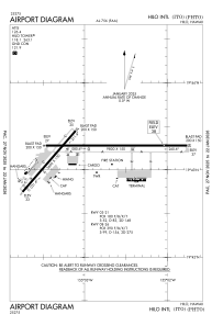


PHTO - Hilo Intl
Located in Hilo,
ICAO - ITO, IATA - ITO
Data provided by AirmateGeneral information
Coordinates: N19°43'13" W155°2'54"
Elevation is 38 feet MSL.
Magnetic variation is 11° East View others Airports in Hawaii
Operational data
Special qualification required
Current time UTC:
Current local time:
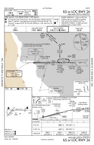
Communications frequencies: [VIEW]
Runways:
| RWY identifier | QFU | Length (ft) | Width (ft) | Surface | LDA (ft) |
| 03 | 41° | 5600 | 150 | ASPH | 5251 |
| 21 | 221° | 5600 | 150 | ASPH | 5510 |
| 08 | 90° | 9800 | 150 | ASPH | 9800 |
| 26 | 270° | 9800 | 150 | ASPH | 9800 |
Airport contact information
Address: Hilo