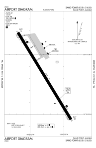


PASD - Sand Point
Located in Sand Point,
ICAO - SDP, IATA - SDP
Data provided by AirmateGeneral information
Coordinates: N55°18'49" W160°31'17"
Elevation is 24 feet MSL.
Magnetic variation is 11° East View others Airports in Alaska
Operational data
Special qualification required
Current time UTC:
Current local time:
Communications frequencies: [VIEW]
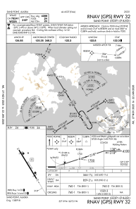
Runways:
| RWY identifier | QFU | Length (ft) | Width (ft) | Surface | LDA (ft) |
| 14 | 148° | 5213 | 150 | ASPH | 4099 |
| 32 | 328° | 5213 | 150 | ASPH | 4099 |
Airport contact information
Address: Sand Point