


PAOM - Nome
Located in Nome,
ICAO - OME, IATA - OME
Data provided by AirmateGeneral information
Coordinates: N64°30'45" W165°26'40"
Elevation is 41 feet MSL.
Magnetic variation is 11° East View others Airports in Alaska
Operational data
Special qualification required
Current time UTC:
Current local time:
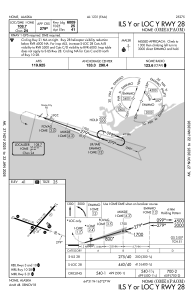
Communications frequencies: [VIEW]
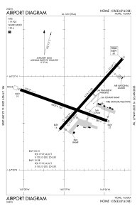
Runways:
| RWY identifier | QFU | Length (ft) | Width (ft) | Surface | LDA (ft) |
| 03 | 42° | 6176 | 150 | ASPH | 5576 |
| 21 | 222° | 6176 | 150 | ASPH | 5576 |
| 10 | 110° | 6009 | 150 | ASPH | 6009 |
| 28 | 290° | 6009 | 150 | ASPH | 6009 |
Airport contact information
Address: Nome