


PABG - Beluga
Located in Beluga,
ICAO - BLG, IATA - BVU
Data provided by AirmateGeneral information
Coordinates: N61°10'23" W151°2'43"
Elevation is 87 feet MSL.
Magnetic variation is 19° East View others Airports in Alaska
Operational data
Special qualification required
Current time UTC:
Current local time:
Communications frequencies: [VIEW]
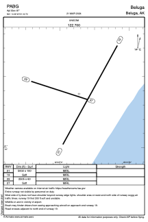
Runways:
| RWY identifier | QFU | Length (ft) | Width (ft) | Surface | LDA (ft) |
| 01 | 29° | 5002 | 100 | GRAVEL | |
| 19 | 209° | 5002 | 100 | GRAVEL | |
| 09 | 108° | 2505 | 60 | GRAVEL | |
| 27 | 288° | 2505 | 60 | GRAVEL | |
| H1 | 0° | 0 | 0 | UNK |
Airport contact information
Address: Beluga