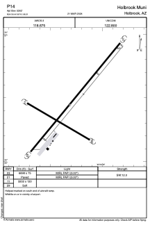


P14 - Holbrook Muni
Located in Holbrook, United States
ICAO - P14, IATA -
Data provided by AirmateGeneral information
Coordinates: N34°56'27" W110°8'19"
Elevation is 5262 feet MSL.
Magnetic variation is 12° East View others Airports in Arizona
Operational data
Special qualification required
Current time UTC:
Current local time:
Weather at : KINW - Winslow-Lindbergh Rgnl ( 54 km )
METAR: KINW 161856Z AUTO 24018G25KT 10SM CLR 36/M11 A2990 RMK AO2 PK WND 25029/1845 SLP031 T03611106 $
TAF: KINW 161720Z 1618/1718 21015G25KT P6SM SKC FM162100 23022G32KT P6SM SKC FM170300 21009KT P6SM SKC FM171100 14007KT P6SM SKC FM171700 20015G25KT P6SM SKC
Communications frequencies: [VIEW]
Runways:
| RWY identifier | QFU | Length (ft) | Width (ft) | Surface | LDA (ft) |
| 03 | 0° | 6698 | 75 | ASPH | |
| 21 | 0° | 6698 | 75 | ASPH | |
| 11 | 0° | 3202 | 120 | OTHER | |
| 29 | 0° | 3202 | 120 | OTHER |
Airport contact information
Address: Holbrook United States