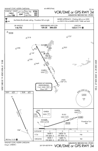


N63 - Meadow Brook Fld
Located in Walnut Cove, United States
ICAO - N63, IATA -
Data provided by AirmateGeneral information
Coordinates: N36°18'5" W80°8'54"
Elevation is 631 feet MSL.
Magnetic variation is -06° East View others Airports in North Carolina
Operational data
Special qualification required
Current time UTC:
Current local time:
Communications frequencies: [VIEW]
Runways:
| RWY identifier | QFU | Length (ft) | Width (ft) | Surface | LDA (ft) |
| 16 | 160° | 2725 | 32 | ASPH | |
| 34 | 340° | 2725 | 32 | ASPH |
Airport contact information
Address: Walnut Cove United States