logo
Search for airport 
image banner adimage banner adimage banner ad
image banner ad

MO2 - Flying Bar H Ranch

Located in Springfield, United States

ICAO - MO2, IATA -

Data provided by Airmate  

General information

Coordinates: N37°10'31" W93°7'44"
Elevation is 1380 feet MSL.
Magnetic variation is 04° East
View others Airports in Missouri

Operational data

Special qualification required
Current time UTC:
Current local time:
Weather at : KSGF - Springfield-Branson Ntl ( 24 km )
METAR: KSGF 081152Z 15009KT 10SM SCT038 SCT050 BKN090 19/19 A2988 RMK AO2 SLP108 60057 70057 T01940189 10233 20194 55020
TAF: KSGF 081134Z 0812/0912 12009KT P6SM BKN100 FM081600 21013G22KT P6SM BKN090 PROB30 0822/0902 4SM TSRA BR OVC025CB FM090200 20005KT P6SM BKN080 PROB30 0902/0903 4SM TSRA BR OVC025CB FM090600 14005KT 4SM TSRA BR VCTS BKN020CB FM090800 36005KT 4SM TSRA BR VCTS OVC006CB FM091000 07005KT 4SM TSRA BR VCTS BKN008CB
View NOTAMs / SUP AIP / TFR affecting this airport [VIEW]
Communications frequencies: [VIEW]
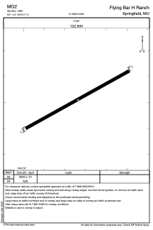
Runways:

RWY identifierQFULength (ft)Width (ft)SurfaceLDA (ft)
06264070GRASS
24264070GRASS

Airport contact information

Address: Springfield United States

Satellite view of MO2