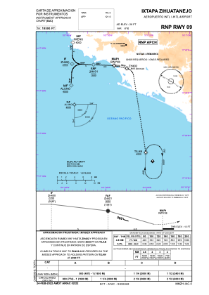
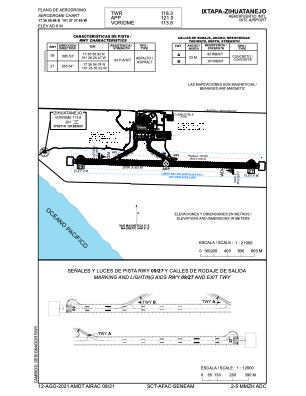


MMZH - Ixtapa-Zihuatanejo Aeropuerto Internacional
Located in Zihuatanejo, Mexico
ICAO - MMZH, IATA - ZIH
Data provided by AirmateGeneral information
Coordinates: N17°36'6" W101°27'38"
Elevation is 26 feet MSL.
View others Airports in Guerrero
Operational data
Special qualification required
Current time UTC:
Current local time:
Weather
METAR: MMZH 151943Z 20007KT 7SM SCT020 32/25 A2975 RMK 8/100 HZY ISOL CI
TAF: TAF MMZH 151651Z 1518/1618 22010KT P6SM SCT020 SCT250 FM160000 22005KT P6SM SCT020 FM161200 34005KT P6SM SCT100 SCT250
Communications frequencies: [VIEW]
Runways:
| RWY identifier | QFU | Length (ft) | Width (ft) | Surface | LDA (ft) |
| 09 | 92° | 8222 | 197 | UNK | |
| 27 | 272° | 8222 | 197 | UNK |
Airport contact information
Address: Zihuatanejo Mexico