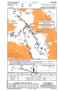
MMTO - Toluca Aeropuerto Internacional Lic. Adolfo Lopez Mateos
Located in Toluca, Mexico
ICAO - MMTO, IATA - TLC
Data provided by AirmateGeneral information
Coordinates: N19°20'14" W99°33'58"
Elevation is 8466 feet MSL.
View others Airports in Mexico
Operational data
Special qualification required
Current time UTC:
Current local time:
Weather
METAR: MMTO 282344Z 18010KT 6SM FEW020 SCT100 BKN200 25/02 A3040 RMK SLP074 54000 954 8/138 CB DSNT N HZY
TAF: TAF MMTO 282256Z 2900/3000 14010KT 6SM HZ SCT020 BKN220 TX26/2919Z TN11/2912Z TEMPO 2900/2904 5SM RA BKN020CB FM290600 00000KT P6SM BKN200 BECMG 2912/2913 06004KT 5SM HZ FM291900 06012KT 6SM HZ BKN020CB BKN220 TEMPO 2920/2924 3SM TSRA BKN015CB
Communications frequencies: [VIEW]
Runways:
| RWY identifier | QFU | Length (ft) | Width (ft) | Surface | LDA (ft) |
| 15 | 157° | 13780 | 148 | ASP | |
| 33 | 337° | 13780 | 148 | ASP |
Airport contact information
Address: Toluca Mexico


