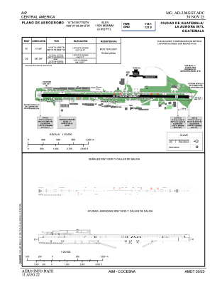


MGGT - La Aurora
Located in Guatemala, Guatemala
ICAO - MGGT, IATA - GUA
Data provided by AirmateGeneral information
Coordinates: N14°35'0" W90°31'39"
Elevation is 4952 feet MSL.
View others Airports in Guatemala
Operational data
Special qualification required
Current time UTC:
Current local time:
Weather
METAR: MGGT 060600Z 18004KT 9999 OVC014 20/19 Q1020 A3012
TAF: MGGT 060500Z 0606/0706 18006KT 9999 SCT014 BKN080 TX28/0620Z TN19/0612Z BECMG 0615/0617 SCT018 TEMPO 0620/0702 8000 TSRA SCT020TCU FEW025CB SCT090 BECMG 0702/0704 SCT016 SCT080
Communications frequencies: [VIEW]
Runways:
| RWY identifier | QFU | Length (ft) | Width (ft) | Surface | LDA (ft) |
| 02 | 17° | 9800 | 197 | UNK | |
| 20 | 197° | 9800 | 197 | UNK |
Airport contact information
Address: Guatemala Guatemala