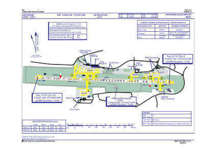


MBPV - Providenciales International
Located in Providenciales, Turks and Caicos Islands
ICAO - MBPV, IATA - PLS
Data provided by AirmateGeneral information
Coordinates: N21°46'26" W72°16'7"
Elevation is 28 feet MSL.
Magnetic variation is -10° East View others Airports in Providenciales
Operational data
Special qualification required
Current time UTC:
Current local time:
Communications frequencies: [VIEW]
Runways:
| RWY identifier | QFU | Length (ft) | Width (ft) | Surface | LDA (ft) |
| 10 | 93° | 9199 | 148 | ASP | |
| 28 | 273° | 9199 | 148 | ASP |
Airport contact information
Address: Providenciales Turks and Caicos Islands