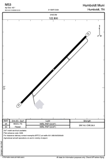


M53 - Humboldt Muni
Located in Humboldt, United States
ICAO - M53, IATA -
Data provided by AirmateGeneral information
Coordinates: N35°48'8" W88°52'30"
Elevation is 421 feet MSL.
Magnetic variation is -02° East View others Airports in Tennessee
Operational data
Special qualification required
Current time UTC:
Current local time:
Communications frequencies: [VIEW]
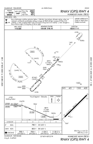
Runways:
| RWY identifier | QFU | Length (ft) | Width (ft) | Surface | LDA (ft) |
| 04 | 44° | 4003 | 75 | ASPH | |
| 22 | 224° | 4003 | 75 | ASPH |
Airport contact information
Address: Humboldt United States