


M48 - Houston Meml
Located in Houston, United States
ICAO - M48, IATA -
Data provided by AirmateGeneral information
Coordinates: N37°19'49" W91°58'23"
Elevation is 1195 feet MSL.
Magnetic variation is 00° East View others Airports in Missouri
Operational data
Special qualification required
Current time UTC:
Current local time:
Weather at : KTBN - Waynesville-St Robert Rgnl Forney Fld ( 48 km )
METAR: KTBN 032155Z AUTO 20006KT 10SM CLR 24/19 A2976 RMK AO2 SLP071 T02350192
TAF: TAF KTBN 032100Z 0321/0503 VRB10G18KT 9000 -SHRA VCTS BKN035CB OVC100 QNH2973INS BECMG 0401/0403 17009KT 9000 -SHRA BR BKN020 OVC040 QNH2973INS BECMG 0411/0413 17006KT 3200 SHRA VCTS BKN004CB OVC015 QNH2974INS BECMG 0419/0421 VRB10G20KT 4800 -TSRA BKN015CB BKN035 OVC100 QNH2973INS BECMG 0501/0503 19006KT 8000 RA BKN011 OVC019 QNH2967INS TX26/0321Z TN22/0409Z LAST NO AMDS AFT 0403 NEXT 0413
Communications frequencies: [VIEW]
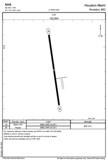
Runways:
| RWY identifier | QFU | Length (ft) | Width (ft) | Surface | LDA (ft) |
| 16 | 172° | 3500 | 60 | CONC | |
| 34 | 352° | 3500 | 60 | CONC |
Airport contact information
Address: Houston United States