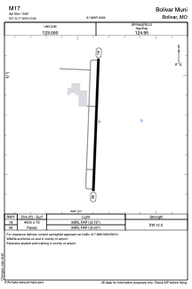


M17 - Bolivar Muni
Located in Bolivar, United States
ICAO - M17, IATA -
Data provided by AirmateGeneral information
Coordinates: N37°35'46" W93°20'52"
Elevation is 1092 feet MSL.
Magnetic variation is 03° East View others Airports in Missouri
Operational data
Special qualification required
Current time UTC:
Current local time:
Weather at : KSGF - Springfield-Branson Ntl ( 39 km )
METAR: KSGF 080652Z AUTO 14011KT 10SM FEW120 23/16 A2984 RMK AO2 SLP090 T02280161
TAF: KSGF 080533Z 0806/0906 16010KT P6SM SCT150 TEMPO 0808/0810 4SM -TSRA BR OVC025CB FM081400 18012G20KT P6SM BKN200 FM081900 24012G20KT P6SM BKN090 PROB30 0822/0824 4SM TSRA BR OVC025CB FM090000 22005KT P6SM BKN180 PROB30 0900/0906 4SM TSRA BR OVC025CB
Communications frequencies: [VIEW]
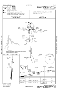
Runways:
| RWY identifier | QFU | Length (ft) | Width (ft) | Surface | LDA (ft) |
| 18 | 183° | 4000 | 75 | ASPH | |
| 36 | 3° | 4000 | 75 | ASPH |
Airport contact information
Address: Bolivar United States
Other aviation service providers
Flight schools

Service Oriented Aviation Readiness (S.O.A.R.)
Service Oriented Aviation Readiness (S.O.A.R.)
kerrick@soar-m17.org+1(417)777-6800