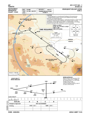


LTCT - Igdir Sehit Bulent Aydin
Located in Igdir, Turkey
ICAO - , IATA - IGD
Data provided by AirmateGeneral information
Coordinates: N39°58'59" E43°51'59"
Elevation is 3102 feet MSL.
Magnetic variation is 6.1° East View others Airports in Igdir
Operational data
Special qualification required
Current time UTC:
Current local time:
Weather
METAR: LTCT 291050Z 12007KT 050V180 9999 FEW040 29/10 Q1014
TAF: TAF LTCT 291040Z 2912/2921 VRB02KT 9999 SCT040 TEMPO 2913/2917 12015G25KT -TSRA FEW030CB
Communications frequencies: [VIEW]
Runways:
| RWY identifier | QFU | Length (ft) | Width (ft) | Surface | LDA (ft) |
| 12 | 129° | 9843 | 148 | CONC | 9843 |
| 30 | 309° | 9843 | 148 | CONC | 9843 |
Airport contact information
Address: Igdir Turkey