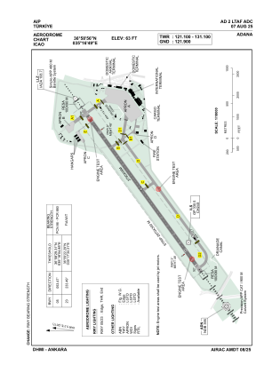


LTAF - Adana
Located in Adana, Turkey
ICAO - LTAF, IATA - ADA
Data provided by AirmateGeneral information
Coordinates: N36°58'56" E35°16'49"
Elevation is 63 feet MSL.
Magnetic variation is 5.3° East View others Airports in Adana
Operational data
Special qualification required
Current time UTC:
Current local time:
Weather
METAR: LTAF 130150Z 20002KT 4200 BR NSC 23/23 Q1011 BECMG TL0300 9999 NSW RMK RWY23 24004KT SKC
TAF: TAF LTAF 122240Z 1300/1324 VRB02KT CAVOK TEMPO 1301/1305 4000 BR SCT020 BECMG 1310/1312 21012KT BECMG 1316/1318 VRB02KT
Communications frequencies: [VIEW]
Runways:
| RWY identifier | QFU | Length (ft) | Width (ft) | Surface | LDA (ft) |
| 05 | 53° | 9022 | 148 | ASPH | 9022 |
| 23 | 233° | 9022 | 148 | ASPH | 9022 |
Airport contact information
Address: Adana Turkey