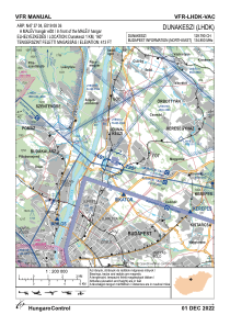
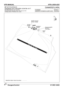


LHDK - Dunakeszi
Located in Dunakeszi, Hungary
ICAO - LHDK, IATA -
Data provided by AirmateGeneral information
Coordinates: N47°37'4" E19°8'36"
Elevation is 413 feet MSL.
Magnetic variation is 3.8° East View others Airports in Pest
Operational data
Special qualification required
Current time UTC:
Current local time:
Weather at : LHBP - Budapest/Liszt Ferenc International Airport ( 22 km )
METAR: LHBP 231300Z 32008KT 280V030 9999 FEW047TCU SCT049 25/11 Q1013 TEMPO FEW045CB
TAF: TAF COR LHBP 231311Z 2312/2412 30008KT CAVOK PROB40 TEMPO 2313/2403 VRB15G28KT 4000 SHRA TSRA SCT040CB BKN060 BECMG 2315/2318 VRB03KT TEMPO 2403/2412 2000 +SHRA TSRA BKN008 BKN020CB BECMG 2407/2410 16006KT
Communications frequencies: [VIEW]
Runways:
| RWY identifier | QFU | Length (ft) | Width (ft) | Surface | LDA (ft) |
| 11 | 0° | 2592 | 98 | GRASS | |
| 29 | 0° | 2592 | 98 | GRASS |
Airport contact information
Address: Dunakeszi Hungary