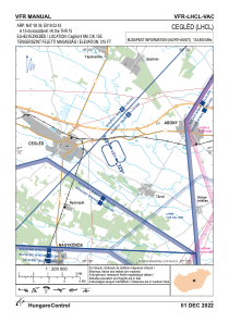


LHCL - Cegled
Located in Cegled, Hungary
ICAO - , IATA -
Data provided by AirmateGeneral information
Coordinates: N47°9'39" E19°52'43"
Elevation is 315 feet MSL.
View others Airports in Pest
Operational data
Special qualification required
Current time UTC:
Current local time:
Weather at : LHSN - Szolnok ( 27 km )
METAR: LHSN 231645Z VRB01KT 9999 FEW035TCU SCT083 BKN200 22/15 Q1014 NOSIG RMK BLU
TAF: TAF LHSN 231415Z 2315/2324 VRB03KT 9999 FEW030 SCT083 BKN200 TEMPO 2315/2324 8000 -SHRA SCT030TCU BKN083 PROB30 TEMPO 2315/2322 VRB13G23KT 6000 SHRA TSRA SCT025CB BKN050 BECMG 2317/2319 CAVOK PROB30 TEMPO 2321/2324 5000 BR MIFG NSC
Communications frequencies: [VIEW]
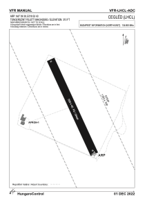
Runways:
| RWY identifier | QFU | Length (ft) | Width (ft) | Surface | LDA (ft) |
| 15 | 0° | 1640 | 131 | GRASS | |
| 33 | 0° | 1640 | 131 | GRASS |
Airport contact information
Address: Cegled Hungary