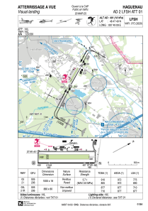


LFSH - Haguenau
Located in Haguenau, France
ICAO - LFSH, IATA -
Data provided by AirmateGeneral information
Coordinates: N48°47'49" E7°49'9"
Elevation is 491 feet MSL.
Magnetic variation is 2.58° East View others Airports in Alsace
Operational data
Special qualification required
Current time UTC:
Current local time:
Weather at : EDSB - Karlsruhe/Baden-Baden ( 19 km )
METAR: EDSB 290950Z 23007KT 190V260 9999 FEW029 OVC043 18/12 Q1015
TAF: TAF EDSB 290500Z 2906/3006 21006KT 9999 SCT040 BECMG 2907/2909 21011KT TEMPO 2912/2918 RA SCT008 BKN012 BECMG 2917/2919 21006KT PROB40 TEMPO 2918/3006 SHRA SCT003 BKN013CB
Communications frequencies: [VIEW]
Runways:
| RWY identifier | QFU | Length (ft) | Width (ft) | Surface | LDA (ft) |
| 03L | 29° | 2887 | 262 | GRASS | 2329 |
| 21R | 209° | 2887 | 262 | GRASS | 2887 |
| 03 | 29° | 3281 | 59 | ASPH | 2625 |
| 21 | 209° | 3281 | 59 | ASPH | 2930 |
Airport contact information
Address: Haguenau France

