logo
Search for airport 
image banner adimage banner adimage banner ad
image banner ad

LFQT - Merville Calonne

Located in Merville, France

ICAO - LFQT, IATA - HZB

Data provided by Airmate  

General information

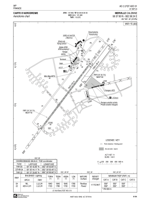
Coordinates: N50°36'60" E2°38'24"
Elevation is 61 feet MSL.
Magnetic variation is 1.02° East
Rated:
View ratings:
[VIEW]
View others Airports in Nord-Pas-de-Calais
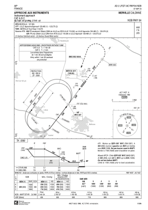
Operational data

Special qualification required
Current time UTC:
Current local time:
Weather at : LFQQ - Lille Lesquin ( 32 km )
METAR: LFQQ 151830Z AUTO 20012KT 9999 FEW030/// BKN078/// OVC100/// //////TCU 15/11 Q1005 TEMPO VRB15G25KT 3000 SHRA SCT008 BKN012 BKN020CB
TAF: TAF LFQQ 151700Z 1518/1624 22011KT 9999 SCT030 TEMPO 1518/1603 3000 SHRA BKN012 BKN020TCU PROB30 TEMPO 1518/1520 VRB15G25KT 1000 TSRA SCT008 BKN012 BKN020CB TEMPO 1603/1610 BKN008 BKN012 TEMPO 1610/1616 VRB15G25KT 3000 SHRA SCT013 BKN020TCU
View NOTAMs / SUP AIP / TFR affecting this airport [VIEW]
Communications frequencies: [VIEW]
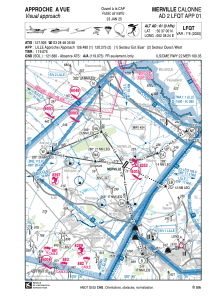
Runways:

RWY identifierQFULength (ft)Width (ft)SurfaceLDA (ft)
04R37°3281262GRASS3281
22L217°3281262GRASS3281
0437°603798ASPH5840
22217°603798ASPH5643

Airport contact information

Address: Merville France

Handlers

CCFL (Communauté de Communes Flandres-Lys)

CCFL (Communauté de Communes Flandres-Lys)
Rated:
View ratings:
[VIEW]

Fuel provider

TotalEnergies

TotalEnergies
+33 320636856

Other aviation service providers

Aviation club (not for profit)

Aéroclub de la Lys et de l'Artois

Aéroclub de la Lys et de l'Artois

Cercle Aérien de Lestrem

Cercle Aérien de Lestrem

Les Ailes de Paradis

Les Ailes de Paradis
ladp.ulm@orange.fr+33686277994

Satellite view of LFQT