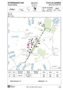


LFJT - Tours Le Louroux
Located in Tours, France
ICAO - LFJT, IATA -
Data provided by AirmateGeneral information
Coordinates: N47°9'0" E0°42'46"
Elevation is 413 feet MSL.
Magnetic variation is 0.63° East View others Airports in Centre
Operational data
Special qualification required
Current time UTC:
Current local time:
Weather at : LFOT - Tours Val De Loire ( 31 km )
TAF: TAF LFOT 282300Z 2900/2924 24010KT 9999 BKN050 PROB40 TEMPO 2900/2905 -RA BKN014 PROB30 TEMPO 2903/2905 BKN006 TEMPO 2905/2913 3000 -RADZ BKN006 PROB30 TEMPO 2913/2924 3000 -RADZ BKN003
Communications frequencies: [VIEW]
Runways:
| RWY identifier | QFU | Length (ft) | Width (ft) | Surface | LDA (ft) |
| 03 | 31° | 2953 | 295 | GRASS | 2641 |
| 21 | 211° | 2953 | 295 | GRASS | 2559 |
Airport contact information
Address: Tours France