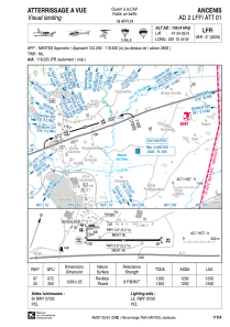


LFFI - Ancenis
Located in Ancenis, France
ICAO - LFFI, IATA -
Data provided by AirmateGeneral information
Coordinates: N47°24'26" W1°10'44"
Elevation is 109 feet MSL.
Magnetic variation is 0.03° East View others Airports in Pays-de-la-Loire
Operational data
Special qualification required
Current time UTC:
Current local time:
Communications frequencies: [VIEW]
Runways:
| RWY identifier | QFU | Length (ft) | Width (ft) | Surface | LDA (ft) |
| 07 | 72° | 3937 | 82 | ASPH | 3937 |
| 25 | 252° | 3937 | 82 | ASPH | 3937 |
Airport contact information
Address: Ancenis France

