logo
Search for airport 
image banner adimage banner adimage banner ad
image banner ad

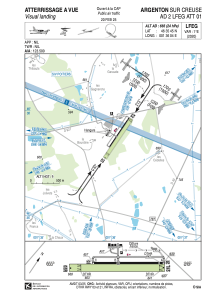
LFEG - Argenton Sur Creuse

Located in Argenton, France

ICAO - LFEG, IATA -

Data provided by Airmate  

General information

Coordinates: N46°35'45" E1°36'4"
Elevation is 666 feet MSL.
Magnetic variation is 0.92° East
View others Airports in Centre

Operational data

Special qualification required
Current time UTC:
Current local time:
Weather at : LFLX - Chateauroux Deols ( 31 km )
METAR: LFLX 181830Z AUTO 31004KT CAVOK 22/18 Q1011 TEMPO VRB15G30KT 2500 TSRAGR BKN050CB
TAF: TAF LFLX 181700Z 1818/1924 VRB03KT 9999 FEW030 TEMPO 1818/1904 -SHRA SCT060CB PROB40 TEMPO 1818/1822 VRB15G30KT 2500 TSRAGR BKN050CB PROB40 TEMPO 1909/1921 -SHRA BKN030TCU PROB30 TEMPO 1912/1921 4000 -TSRA BKN025CB
View NOTAMs / SUP AIP / TFR affecting this airport [VIEW]
Communications frequencies: [VIEW]

Runways:

RWY identifierQFULength (ft)Width (ft)SurfaceLDA (ft)
0434°206759ASPH
22214°206759ASPH
04R34°2723213GRASS
22L214°2723213GRASS

Airport contact information

Address: Argenton France

Other aviation service providers

Aviation club (not for profit)

Aéroclub Vallée de la Creuse

Aéroclub Vallée de la Creuse

Aviation medical examiner

Dr Valette Henri

Dr Valette Henri
+33 254011717

Satellite view of LFEG