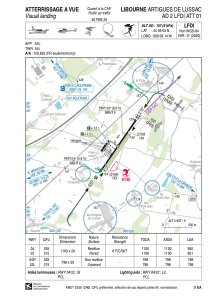


LFDI - Libourne Artigues De Lussac
Located in Libourne, France
ICAO - LFDI, IATA - XLR
Data provided by AirmateGeneral information
Coordinates: N44°59'3" W0°8'14"
Elevation is 157 feet MSL.
Magnetic variation is 0.49° East View others Airports in Aquitaine
Operational data
Special qualification required
Current time UTC:
Current local time:
Weather at : LFBD - Bordeaux Merignac ( 49 km )
METAR: LFBD 081100Z AUTO 31006KT 280V340 CAVOK 27/19 Q1011 TEMPO 4000 SHRA BKN020TCU
TAF: TAF LFBD 080500Z 0806/0912 02005KT CAVOK TX28/0814Z TN16/0906Z TEMPO 0806/0810 4000 SHRA BKN060TCU PROB40 TEMPO 0807/0809 2000 TSRA BKN050CB PROB40 TEMPO 0810/0812 4000 SHRA BKN020TCU TEMPO 0903/0906 -SHRA BKN090TCU
Communications frequencies: [VIEW]
Runways:
| RWY identifier | QFU | Length (ft) | Width (ft) | Surface | LDA (ft) |
| 04 | 35° | 3609 | 66 | ASPH | 3117 |
| 22 | 215° | 3609 | 66 | ASPH | 2789 |
| 04R | 35° | 2618 | 164 | GRASS | 2625 |
| 22L | 215° | 2618 | 164 | GRASS | 2625 |
Airport contact information
Address: Libourne France