logo
Search for airport 
image banner adimage banner adimage banner ad
image banner ad

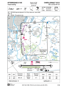
LFCA - Chatellerault Targe

Located in Chatellerault, France

ICAO - LFCA, IATA - XCX

Data provided by Airmate  

General information

Coordinates: N46°46'49" E0°33'2"
Elevation is 210 feet MSL.
Magnetic variation is 0.60° East
Rated:
View ratings:
[VIEW]
View others Airports in Poitou-Charentes

Operational data

Special qualification required
Current time UTC:
Current local time:
Weather at : LFBI - Poitiers Biard ( 28 km )
METAR: LFBI 171200Z AUTO 20008KT 160V240 9999 SCT022 SCT074 22/16 Q1012 TEMPO 4500 -SHRA BKN020TCU
TAF: TAF LFBI 171100Z 1712/1812 20008KT 9999 BKN020 PROB30 TEMPO 1712/1718 4500 -SHRA BKN020TCU TEMPO 1723/1805 4000 SHRA SCT012 BKN050CB PROB40 TEMPO 1800/1804 VRB15G35KT 1500 TSRAGR SCT012 BKN020CB
View NOTAMs / SUP AIP / TFR affecting this airport [VIEW]
Communications frequencies: [VIEW]

Runways:

RWY identifierQFULength (ft)Width (ft)SurfaceLDA (ft)
18177°262566ASPH2454
36357°262566ASPH2625

Airport contact information

Address: Chatellerault France

Other aviation service providers

Aviation club (not for profit)

Les Ailes Chatelleraudaises

Les Ailes Chatelleraudaises

Satellite view of LFCA