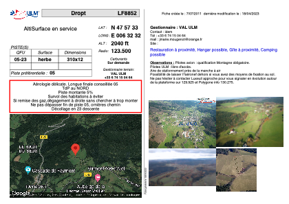


LF8852 - Dropt
Located in Girmont-Val-d'Ajol, France
ICAO - , IATA -
Data provided by AirmateGeneral information
Coordinates: N47°57'33" E6°32'32"
Elevation is 2040 feet MSL.
View others Airports in Lorraine
Operational data
Special qualification required
Current time UTC:
Current local time:
Communications frequencies: [VIEW]
Runways:
| RWY identifier | QFU | Length (ft) | Width (ft) | Surface | LDA (ft) |
| 05 | 0° | 1017 | 39 | GRASS | |
| 23 | 0° | 1017 | 39 | GRASS |
Airport contact information
Address: Girmont-Val-d'Ajol France