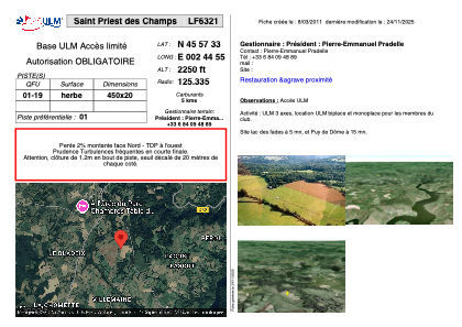


LF6321 - Saint Priest des Champs
Located in Saint-Priest-des-Champs, France
ICAO - , IATA -
Data provided by AirmateGeneral information
Coordinates: N45°57'32" E2°44'56"
Elevation is 2250 feet MSL.
View others Airports in Limousin
Operational data
Special qualification required
Current time UTC:
Current local time:
Weather at : LFLC - Clermont Ferrand Auvergne ( 37 km )
METAR: LFLC 160230Z AUTO 20005KT 170V230 9999 FEW046 11/08 Q1013 NOSIG
TAF: TAF LFLC 152300Z 1600/1624 18008KT 9999 SCT045 BECMG 1609/1611 24010KT TEMPO 1611/1615 25015G25KT BECMG 1620/1622 VRB03KT
Communications frequencies: [VIEW]
Runways:
| RWY identifier | QFU | Length (ft) | Width (ft) | Surface | LDA (ft) |
| 01 | 0° | 1148 | 65 | GRASS | |
| 19 | 0° | 1148 | 65 | GRASS |
Airport contact information
Address: Saint-Priest-des-Champs France