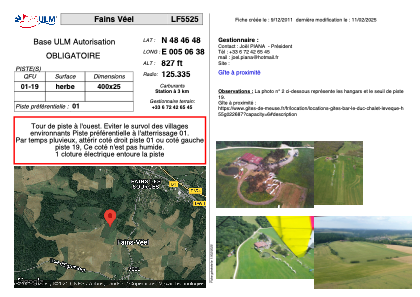


LF5525 - Fains Véel
Located in Fains-Veel, France
ICAO - , IATA -
Data provided by AirmateGeneral information
Coordinates: N48°46'48" E5°6'38"
Elevation is 827 feet MSL.
View others Airports in Lorraine
Operational data
Special qualification required
Current time UTC:
Current local time:
Weather at : LFSI - Saint Dizier Robinson ( 22 km )
METAR: LFSI 011530Z AUTO 29009KT 9999 BKN010 OVC021 15/13 Q1019
TAF: TAF LFSI 011400Z 0115/0215 32008KT 9999 SCT010 BKN015 BKN040 BECMG 0115/0117 BKN004 OVC011 TEMPO 0117/0205 2000 BR BKN002 BKN005 BECMG 0205/0207 BKN008 OVC030 BECMG 0207/0209 SCT009 BKN016 BKN035
Communications frequencies: [VIEW]
Runways:
| RWY identifier | QFU | Length (ft) | Width (ft) | Surface | LDA (ft) |
| 01 | 0° | 1312 | 82 | GRASS | |
| 19 | 0° | 1312 | 82 | GRASS |
Airport contact information
Address: Fains-Veel France