


LF5021 - Dragey
Located in Dragey, France
ICAO - , IATA -
Data provided by AirmateGeneral information
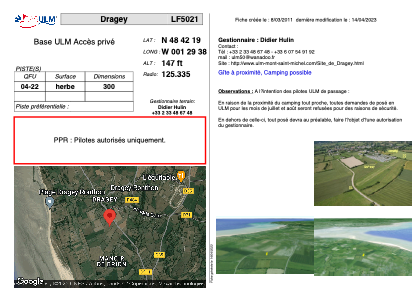
Coordinates: N48°42'19" W1°29'38"
Elevation is 147 feet MSL.
View others Airports in Lower Normandy
Operational data
Special qualification required
Current time UTC:
Current local time:
Weather at : LFRD - Dinard Pleurtuit Saint Malo ( 45 km )
METAR: LFRD 121200Z AUTO 35013KT 310V020 9999 FEW012 16/07 Q1023 NOSIG
TAF: TAF LFRD 121100Z 1212/1312 33010KT 9999 SCT040 BECMG 1218/1221 VRB05KT PROB40 TEMPO 1223/1305 4000 BR BECMG 1306/1308 17010KT BECMG 1310/1312 21015G25KT
Communications frequencies: [VIEW]
Runways:
| RWY identifier | QFU | Length (ft) | Width (ft) | Surface | LDA (ft) |
| 04 | 0° | 984 | 0 | GRASS | |
| 22 | 0° | 984 | 0 | GRASS |
Airport contact information
Address: Dragey France