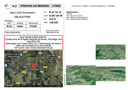


LF3652 - Villentrois Les Mardelles
Located in Villentrois, France
ICAO - , IATA -
Data provided by AirmateGeneral information
Coordinates: N47°10'12" E1°26'40"
Elevation is 413 feet MSL.
View others Airports in Centre
Operational data
Special qualification required
Current time UTC:
Current local time:
Weather at : LFYR - Romorantin Pruniers ( 25 km )
METAR: LFYR 031100Z AUTO VRB03KT 9999 FEW029 18/10 Q1021 NOSIG
TAF: TAF LFYR 030800Z 0309/0409 36005KT CAVOK TEMPO 0400/0405 2000 BR
Communications frequencies: [VIEW]
Runways:
| RWY identifier | QFU | Length (ft) | Width (ft) | Surface | LDA (ft) |
| 05 | 0° | 885 | 98 | GRASS | |
| 23 | 0° | 885 | 98 | GRASS |
Airport contact information
Address: Villentrois France