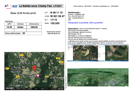


LF3557 - La Baillée sous Champ Fleu
Located in Liffré, France
ICAO - , IATA -
Data provided by AirmateGeneral information
Coordinates: N48°11'15" W1°29'47"
Elevation is 171 feet MSL.
View others Airports in Brittany
Operational data
Special qualification required
Current time UTC:
Current local time:
Weather at : LFRN - Rennes Saint Jacques ( 22 km )
METAR: LFRN 290030Z AUTO 21007KT 9999 OVC007 14/14 Q1016 TEMPO 2000 DZ OVC004
TAF: TAF LFRN 282300Z 2900/2924 22010KT 9999 OVC011 TEMPO 2900/2912 2000 DZ OVC004 BECMG 2905/2907 VRB05KT BECMG 2912/2914 BKN013 TEMPO 2912/2918 32010KT 4000 RA BKN008 BECMG 2918/2920 31008KT BKN016
Communications frequencies: [VIEW]
Runways:
| RWY identifier | QFU | Length (ft) | Width (ft) | Surface | LDA (ft) |
| 12 | 0° | 590 | 131 | GRASS | |
| 30 | 0° | 590 | 131 | GRASS |
Airport contact information
Address: Liffré France