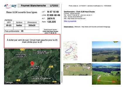


LF2553 - Fournet Blancheroche
Located in Fournet-Blancheroche, France
ICAO - , IATA -
Data provided by AirmateGeneral information
Coordinates: N47°10'40" E6°48'49"
Elevation is 2874 feet MSL.
View others Airports in Franche-Comté
Operational data
Special qualification required
Current time UTC:
Current local time:
Weather at : LSGC - Les Eplatures ( 11 km )
METAR: LSGC 171320Z VRB03KT 9999 FEW015 15/13 Q1018
TAF: TAF LSGC 171125Z 1712/1721 23005KT 9999 BKN015 PROB40 TEMPO 1712/1714 SHRA
Communications frequencies: [VIEW]
Runways:
| RWY identifier | QFU | Length (ft) | Width (ft) | Surface | LDA (ft) |
| 05 | 0° | 1082 | 65 | GRASS | |
| 23 | 0° | 1082 | 65 | GRASS |
Airport contact information
Address: Fournet-Blancheroche France