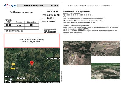


LF1953 - Pérols sur Vézère
Located in Pérols-sur-Vézère, France
ICAO - , IATA -
Data provided by AirmateGeneral information
Coordinates: N45°35'14" E2°0'48"
Elevation is 2800 feet MSL.
View others Airports in Limousin
Operational data
Special qualification required
Current time UTC:
Current local time:
Weather at : LFBL - Limoges Bellegarde ( 71 km )
METAR: LFBL 160500Z AUTO 18009KT 160V220 9999 -RA OVC012 11/11 Q1012 TEMPO 2000 BKN003
TAF: TAF LFBL 152300Z 1600/1624 22010KT 9999 BKN030 BECMG 1601/1603 OVC015 TEMPO 1603/1616 4000 -RA BKN005 PROB40 TEMPO 1605/1615 2000 BKN003 BECMG 1616/1618 CAVOK TEMPO 1618/1624 3000 BR PROB40 TEMPO 1621/1624 4000 SHRA BKN040TCU
Communications frequencies: [VIEW]
Runways:
| RWY identifier | QFU | Length (ft) | Width (ft) | Surface | LDA (ft) |
| 05 | 0° | 820 | 0 | DIRT | |
| 23 | 0° | 820 | 0 | DIRT |
Airport contact information
Address: Pérols-sur-Vézère France