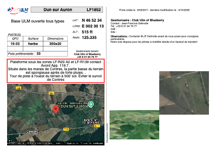


LF1852 - Dun sur Auron
Located in Dun-sur-Auron, France
ICAO - , IATA -
Data provided by AirmateGeneral information
Coordinates: N46°52'34" E2°30'13"
Elevation is 515 feet MSL.
View others Airports in Centre
Operational data
Special qualification required
Current time UTC:
Current local time:
Weather at : LFOA - Avord ( 23 km )
METAR: LFOA 291000Z AUTO 24010KT 9999 SCT020 BKN028 BKN034 17/13 Q1017 TEMPO 4000 RA BKN010
TAF: TAF LFOA 290800Z 2909/3009 24010KT 9999 SCT010 BKN020 BKN080 TX18/2913Z TN13/3005Z TEMPO 2909/2915 4000 RA BKN010 TEMPO 2915/3005 3000 RADZ BKN005 BKN010 PROB40 TEMPO 2916/3001 BKN003 TEMPO 3005/3009 BKN007
Communications frequencies: [VIEW]
Runways:
| RWY identifier | QFU | Length (ft) | Width (ft) | Surface | LDA (ft) |
| 15 | 0° | 1148 | 65 | GRASS | |
| 33 | 0° | 1148 | 65 | GRASS |
Airport contact information
Address: Dun-sur-Auron France