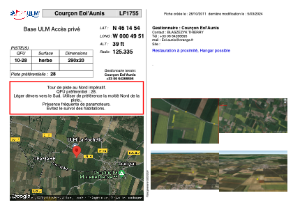


LF1755 - Courçon Eol'Aunis
Located in Courçon d'Aunis, France
ICAO - , IATA -
Data provided by AirmateGeneral information
Coordinates: N46°14'54" W0°49'51"
Elevation is 39 feet MSL.
View others Airports in Pays-de-la-Loire
Operational data
Special qualification required
Current time UTC:
Current local time:
Weather at : LFBH - La Rochelle Ile De Re ( 29 km )
TAF: TAF LFBH 230500Z 2306/2406 14004KT 9999 SCT040 TEMPO 2306/2314 SHRA BKN020CB BECMG 2311/2313 28010KT BECMG 2321/2324 VRB03KT
Communications frequencies: [VIEW]
Runways:
| RWY identifier | QFU | Length (ft) | Width (ft) | Surface | LDA (ft) |
| 10 | 0° | 951 | 65 | GRASS | |
| 28 | 0° | 951 | 65 | GRASS |
Airport contact information
Address: Courçon d'Aunis France