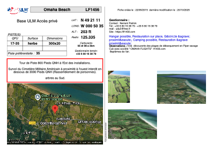


LF1456 - Omaha Beachh
Located in Colleville-sur-Mer, France
ICAO - , IATA -
Data provided by AirmateGeneral information
Coordinates: N49°21'11" W0°50'35"
Elevation is 203 feet MSL.
View others Airports in Lower Normandy
Operational data
Special qualification required
Current time UTC:
Current local time:
Weather at : LFRK - Caen Carpiquet ( 35 km )
TAF: TAF LFRK 131400Z 1315/1324 20014KT 9999 SCT045 BECMG 1315/1318 21015G25KT TEMPO 1316/1321 -RA TEMPO 1321/1324 4000 RADZ OVC012 PROB40 TEMPO 1322/1324 2000 RADZ OVC008
Communications frequencies: [VIEW]
Runways:
| RWY identifier | QFU | Length (ft) | Width (ft) | Surface | LDA (ft) |
| 17 | 0° | 984 | 65 | GRASS | |
| 35 | 0° | 984 | 65 | GRASS |
Airport contact information
Address: Colleville-sur-Mer France
Web: https://lf1456.com