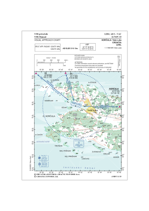
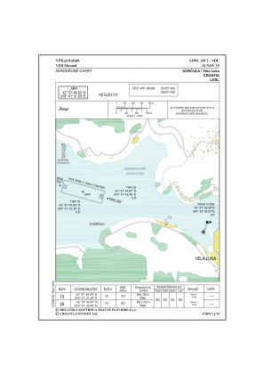


LDSL - Water Aerodrome Korcula/Vela Luka
Located in Vela Luka, Croatia
ICAO - , IATA -
Data provided by AirmateGeneral information
Coordinates: N42°57'47" E16°41'32"
Elevation is 151 feet MSL.
Magnetic variation is 5° East View others Airports in Split-Dalmatia
Operational data
Special qualification required
Current time UTC:
Current local time:
Weather at : LDSB - Brac / Brac I. ( 36 km )
METAR: LDSB 051100Z 20008KT 180V250 9999 FEW025 22/11 Q1018
TAF: TAF LDSB 050525Z 0506/0606 24005KT 9999 FEW030 TX25/0512Z TN18/0603Z PROB40 0509/0514 24008KT
Communications frequencies: [VIEW]
Runways:
| RWY identifier | QFU | Length (ft) | Width (ft) | Surface | LDA (ft) |
| 10 | 106° | 1640 | 0 | WATER | 1640 |
| 28 | 286° | 1640 | 0 | WATER | 1640 |
Airport contact information
Address: Vela Luka Croatia
Web: www.ec-air.eu