


L78 - Jacumba
Located in Jacumba, United States
ICAO - L78, IATA -
Data provided by AirmateGeneral information
Coordinates: N32°36'57" W116°9'56"
Elevation is 2844 feet MSL.
Magnetic variation is 13° East View others Airports in California
Operational data
Special qualification required
Current time UTC:
Current local time:
Weather at : KNJK - El Centro Naf (Vraciu Fld) ( 52 km )
TAF: TAF KNJK 2823/2923 27014G23KT 9999 FEW250 520004 QNH2974INS FM290000 27015G25KT 9999 SCT250 520004 QNH2974INS TEMPO 2905/2907 26014KT FM290700 27009KT 99999 SCT250 510003 QNH2982INS FM291300 VRB05KT 99999 FEW250 500000 QNH2981INS FM291700 06007KT 99999 FEW250 QNH2972INS AUTOMATED SENSOR METWATCH 2906 TIL 2913 TX39/2823Z TN21/2913Z FS30152
Communications frequencies: [VIEW]
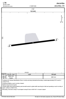
Runways:
| RWY identifier | QFU | Length (ft) | Width (ft) | Surface | LDA (ft) |
| 07 | 0° | 2562 | 60 | ASPH | |
| 25 | 0° | 2562 | 60 | ASPH |
Airport contact information
Address: Jacumba United States