


L33 - Tensas Parish
Located in St Joseph, United States
ICAO - L33, IATA -
Data provided by AirmateGeneral information
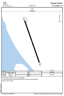
Coordinates: N31°58'24" W91°14'19"
Elevation is 74 feet MSL.
Magnetic variation is 04° East View others Airports in Louisiana
Operational data
Special qualification required
Current time UTC:
Current local time:
Weather at : KHEZ - Hardy-Anders Fld/Natchez-Adams County ( 40 km )
METAR: KHEZ 230656Z AUTO 05006KT 10SM FEW026 24/22 A2996 RMK AO2 LTG DSNT N SLP144 T02440217
TAF: KHEZ 230535Z 2306/2406 15007KT P6SM BKN100 FM230700 16006KT P6SM BKN250 FM231700 19008KT P6SM SCT070
Communications frequencies: [VIEW]
Runways:
| RWY identifier | QFU | Length (ft) | Width (ft) | Surface | LDA (ft) |
| 16 | 0° | 3509 | 75 | ASPH | |
| 34 | 0° | 3509 | 75 | ASPH |
Airport contact information
Address: St Joseph United States