


KWBW - Wilkes-Barre Wyoming Valley
Located in Wilkes-Barre, United States
ICAO - WBW, IATA - WBW
Data provided by AirmateGeneral information
Coordinates: N41°17'50" W75°51'8"
Elevation is 543 feet MSL.
Magnetic variation is -12° East View others Airports in Pennsylvania
Operational data
Special qualification required
Current time UTC:
Current local time:
Communications frequencies: [VIEW]
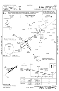
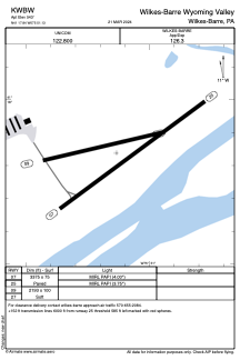
Runways:
| RWY identifier | QFU | Length (ft) | Width (ft) | Surface | LDA (ft) |
| 07 | 54° | 3375 | 75 | ASPH | |
| 25 | 234° | 3375 | 75 | ASPH | |
| 09 | 77° | 2193 | 100 | OTHER | |
| 27 | 257° | 2193 | 100 | OTHER |
Airport contact information
Address: Wilkes-Barre United States
