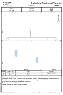


KTNT - Dade-Collier Training And Transition
Located in Miami, United States
ICAO - TNT, IATA -
Data provided by AirmateGeneral information
Coordinates: N25°51'43" W80°53'49"
Elevation is 12 feet MSL.
Magnetic variation is -05° East View others Airports in Florida
Operational data
Special qualification required
Current time UTC:
Current local time:
Weather at : KTMB - Miami Exec ( 52 km )
TAF: KTMB 030057Z 0300/0324 10012KT P6SM VCSH SCT030 BKN050 TEMPO 0301/0302 6SM SHRA BKN025 FM030200 10005KT P6SM VCSH SCT030 SCT250 FM031500 08009KT P6SM VCTS SCT025CB BKN050 FM032100 08008KT P6SM VCSH SCT030 OVC050
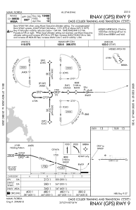
Communications frequencies: [VIEW]
Runways:
| RWY identifier | QFU | Length (ft) | Width (ft) | Surface | LDA (ft) |
| 09 | 90° | 10499 | 150 | ASPH | |
| 27 | 270° | 10499 | 150 | ASPH |
Airport contact information
Address: Miami United States