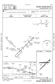
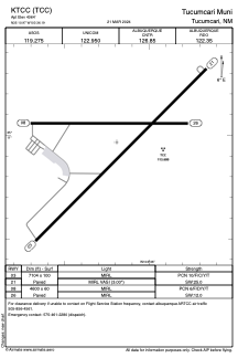


KTCC - Tucumcari Muni
Located in Tucumcari, United States
ICAO - TCC, IATA - TCC
Data provided by AirmateGeneral information
Coordinates: N35°10'58" W103°36'11"
Elevation is 4064 feet MSL.
Magnetic variation is 12° East View others Airports in New Mexico
Operational data
Special qualification required
Current time UTC:
Current local time:
Weather
METAR: KTCC 290119Z AUTO 06020G32KT 10SM VCTS BKN042 21/M02 A3008 RMK AO2 PK WND 06041/0103 WSHFT 0050 LTG DSNT N AND NE T02111022
TAF: KTCC 282337Z 2900/2924 12024G31KT P6SM SCT020 FM290300 11014G22KT P6SM BKN030 FM290800 10007KT P6SM OVC030 FM291700 18006KT P6SM BKN040 FM292000 19010KT P6SM SCT040
Communications frequencies: [VIEW]
Runways:
| RWY identifier | QFU | Length (ft) | Width (ft) | Surface | LDA (ft) |
| 03 | 45° | 7104 | 100 | ASPH | |
| 21 | 225° | 7104 | 100 | ASPH | |
| 08 | 90° | 4600 | 60 | ASPH | |
| 26 | 270° | 4600 | 60 | ASPH |
Airport contact information
Address: Tucumcari United States