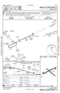
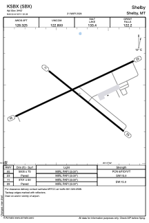


KSBX - Shelby
Located in Shelby, United States
ICAO - SBX, IATA - SBX
Data provided by AirmateGeneral information
Coordinates: N48°32'26" W111°52'17"
Elevation is 3442 feet MSL.
Magnetic variation is 15° East View others Airports in Montana
Operational data
Special qualification required
Current time UTC:
Current local time:
Weather at : KCTB - Cut Bank Intl ( 38 km )
METAR: KCTB 040856Z AUTO 25029G38KT 10SM BKN090 07/M01 A2960 RMK AO2 PK WND 27038/0758 SLP013 T00721006 53013
TAF: KCTB 040527Z 0406/0506 27034G55KT P6SM FEW050 SCT160 FM041600 26038G60KT P6SM FEW090 FEW240 FM050000 26031G48KT P6SM FEW050 FEW250 FM050300 26027G40KT P6SM FEW050 FEW250
Communications frequencies: [VIEW]
Runways:
| RWY identifier | QFU | Length (ft) | Width (ft) | Surface | LDA (ft) |
| 05 | 65° | 5005 | 75 | ASPH | |
| 23 | 245° | 5005 | 75 | ASPH | |
| 11 | 129° | 3701 | 60 | ASPH | |
| 29 | 309° | 3701 | 60 | ASPH |
Airport contact information
Address: Shelby United States