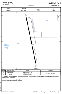


KRBL - Red Bluff Muni
Located in Red Bluff, United States
ICAO - RBL, IATA -
Data provided by AirmateGeneral information
Coordinates: N40°9'1" W122°15'8"
Elevation is 352 feet MSL.
Magnetic variation is 17° East View others Airports in California
Operational data
Special qualification required
Current time UTC:
Current local time:
Communications frequencies: [VIEW]
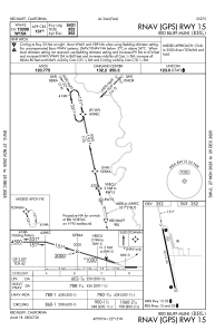
Runways:
| RWY identifier | QFU | Length (ft) | Width (ft) | Surface | LDA (ft) |
| 15 | 168° | 5431 | 100 | ASPH | |
| 33 | 348° | 5431 | 100 | ASPH | |
| H1 | 0° | 0 | 0 | UNK |
Airport contact information
Address: Red Bluff United States