


KPSM - Portsmouth Intl At Pease
Located in Portsmouth, United States
ICAO - PSM, IATA - PSM
Data provided by AirmateGeneral information
Coordinates: N43°4'41" W70°49'24"
Elevation is 100 feet MSL.
Magnetic variation is -16° East View others Airports in New Hampshire
Operational data
Special qualification required
Current time UTC:
Current local time:
Weather
METAR: KPSM 230755Z 24005KT 10SM FEW150 SCT250 20/16 A2978 RMK AO2A SLP086 T01970159
TAF: KPSM 230844Z 2309/2406 23005KT P6SM SCT250 FM231400 25007KT P6SM BKN250 FM231800 22010KT P6SM BKN250 FM240000 26005KT P6SM BKN250
Communications frequencies: [VIEW]
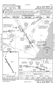
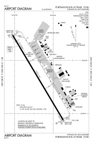
Runways:
| RWY identifier | QFU | Length (ft) | Width (ft) | Surface | LDA (ft) |
| 16 | 149° | 11322 | 150 | OTHER | 10518 |
| 34 | 329° | 11322 | 150 | OTHER | 11321 |
Airport contact information
Address: Portsmouth United States

