


KPIB - Hattiesburg/Laurel Rgnl
Located in Hattiesburg-Laurel, United States
ICAO - PIB, IATA - PIB
Data provided by AirmateGeneral information
Coordinates: N31°28'2" W89°20'13"
Elevation is 297 feet MSL.
Magnetic variation is -01° East View others Airports in Mississippi
Operational data
Special qualification required
Current time UTC:
Current local time:
Communications frequencies: [VIEW]
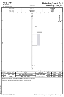
Runways:
| RWY identifier | QFU | Length (ft) | Width (ft) | Surface | LDA (ft) |
| 18 | 180° | 6503 | 150 | ASPH | 6503 |
| 36 | 360° | 6503 | 150 | ASPH | 6503 |
Airport contact information
Address: Hattiesburg-Laurel United States