


KORK - North Little Rock Muni
Located in North Little Rock, United States
ICAO - ORK, IATA -
Data provided by AirmateGeneral information
Coordinates: N34°49'59" W92°15'15"
Elevation is 545 feet MSL.
Magnetic variation is 02° East View others Airports in Arkansas
Operational data
Special qualification required
Current time UTC:
Current local time:
Communications frequencies: [VIEW]
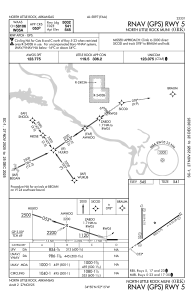
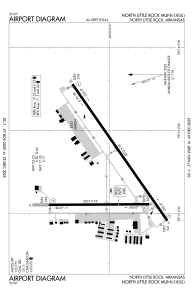
Runways:
| RWY identifier | QFU | Length (ft) | Width (ft) | Surface | LDA (ft) |
| 05 | 55° | 5002 | 75 | CONC | |
| 23 | 235° | 5002 | 75 | CONC | |
| 17 | 180° | 3019 | 75 | ASPH | |
| 35 | 360° | 3019 | 75 | ASPH |
Airport contact information
Address: North Little Rock United States
